by The Goat | Mar 12, 2020 | Ancient Ruins, Cultural History
Exploring the Native Heritage of Arizona
One of the truly special things about the southwest is the myriad of ancient ruins that are easily accessed and well preserved. We here in Arizona are able to enjoy several sites attributed to Hohokam, Anasazi, Sinagua, and Puebloan people that frequented and inhabited the territory over centuries before us. Though many ruin sites are a secret (and need to stay that way), there are several that are large and very well-preserved, and have therefore been designated by various management entities (BLM, NPS, Navajo Nation) for protection. Here are The Goat’s Top 5 Must-See ancient ruins. Enjoy!
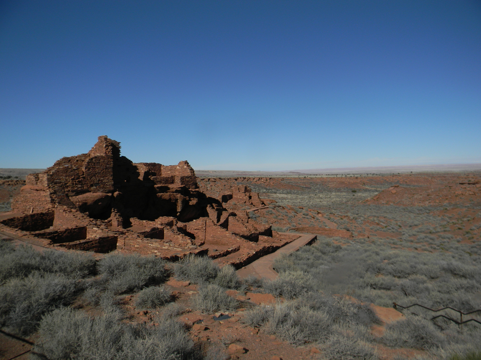
(Cover Photo: Anasazi Dwelling, Wupatki National Monument, Courtesy of The Goat)
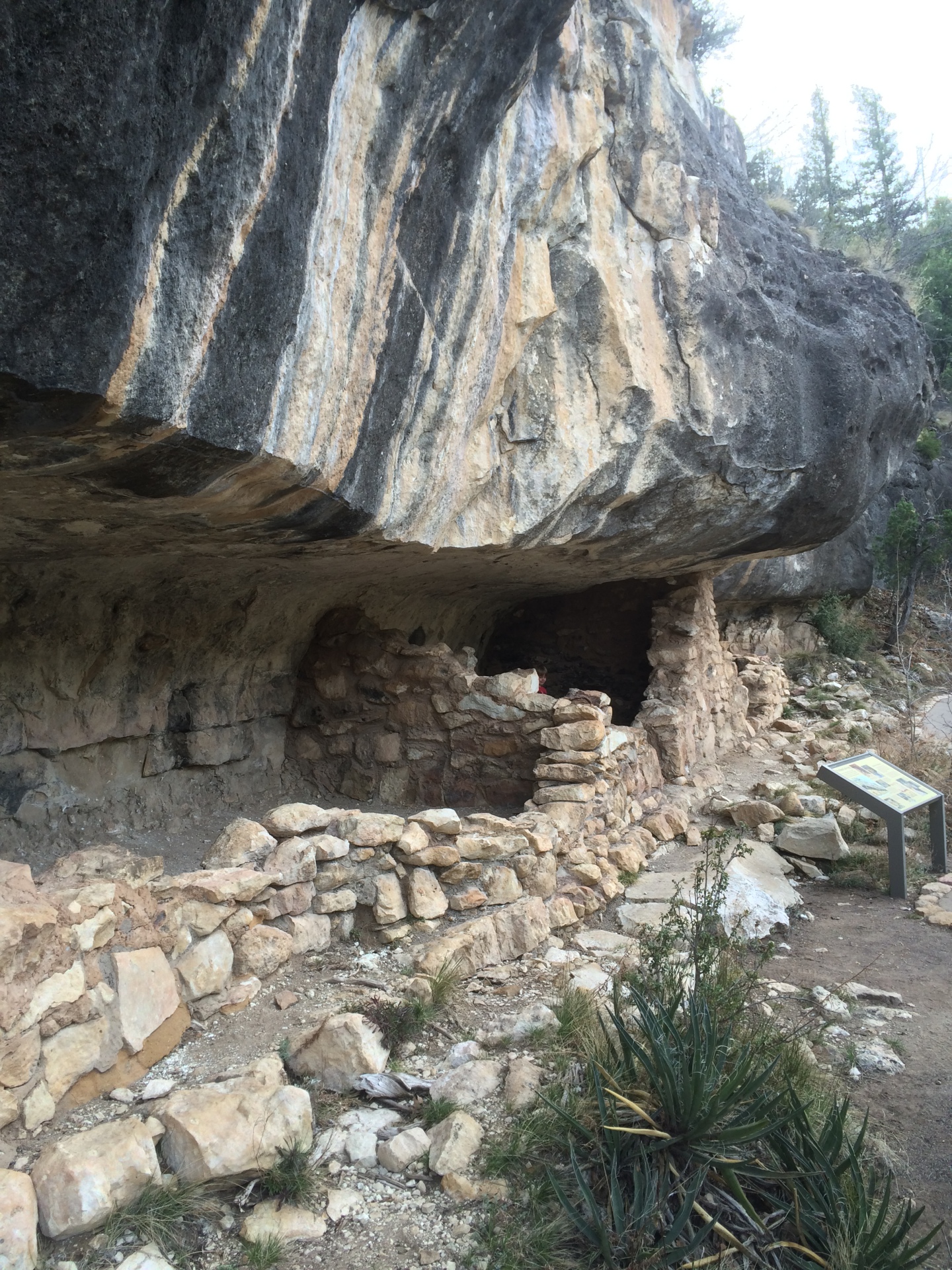
5. Walnut Canyon National Monument
History: These dwellings, ingeniously carved into the steep walls of Walnut Canyon, were inhabited by the Sinagua people between roughly 800-1250 AD, and are thought to have housed several hundred villagers. The Sinaguan were a peaceful tribe that farmed in the area and traded with other tribes. Their rather sudden abandonment of Walnut Canyon is attributed most likely to severe drought, although some theorize that the eruption at Sunset Volcano rendered the region uninhabitable and forced their migration.
Location:About 7 miles east of Flagstaff off I-40
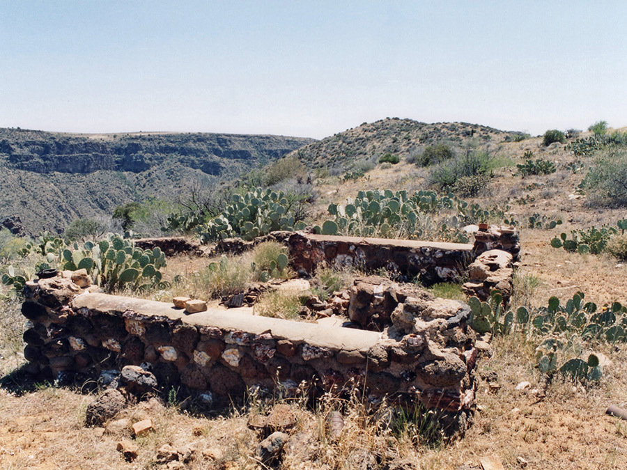
4. Agua Fria National Monument
History: Designated as a National Monument by the Clinton Administration in 1994, Agua Fria is one of the most extensive ruin sites in the southwest. There are more than 450 discernible ruins, several of which include multiple rooms and attachment structures. The region is theorized to have housed several thousand inhabitants between 1250-1450 AD, mostly of Sinaguan or possibly Puebloan tribes. The area itself is marked by rugged canyons, windswept mesas, and hot summer temperatures, making many of the archaeological sites very difficult to access. However, what we find difficult today is likely the very reason this area was chosen: easily defensed, hard to find, and close to the life-giving waters of the Verde River
Location:North of Black Canyon City off I-17
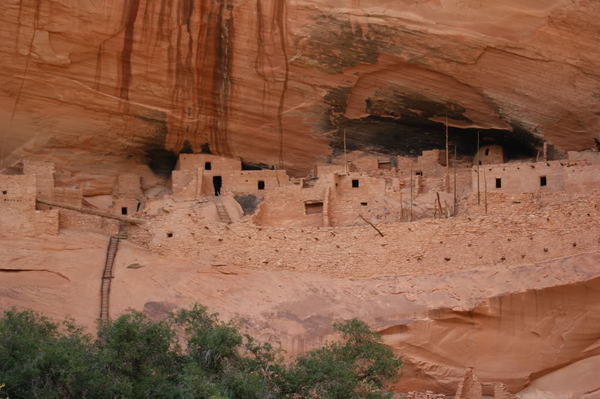
3. Wupatki National Monument
History:Shared by several tribes including the Ancestral Puebloan, Anasazi, and Sinaguan between 800-1250 AD, this impressive group of ruins is remarkably well-preserved, and includes structures that clearly indicate a population of potentially several thousand people. The most impressive of these ruins (pictured above) included nearly 100 rooms, and is theorized to be the central marketplace used for trading, entertainment events, worship, and general gathering. The area was abandoned around 1250 AD, which roughly coincides with the abandonment of the Walnut Canyon Dwellings and the eruption of Sunset Volcano that lies between the two dwelling area, and just 6 miles south of Wupatki.
Location:15 miles north of Flagstaff off Hwy 89A
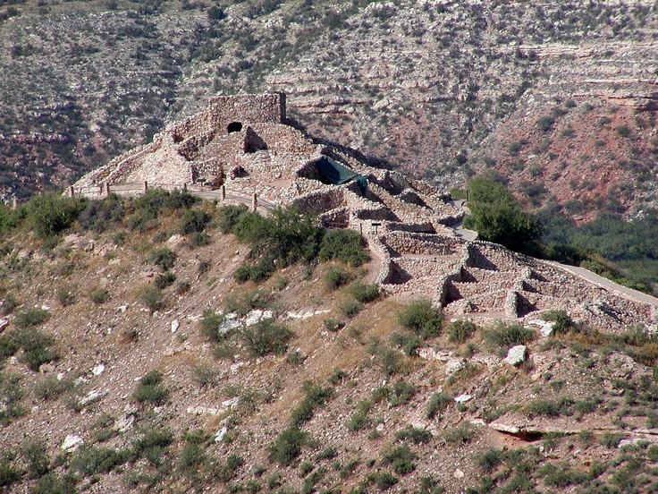
2. Tuzigoot National Monument
History: Yet another pueblo of the Sinaguan culture, Tuzigoot is perhaps their most impressive. Built into the cliffs near Sycamore Canyon, the main ruin at Tuzigoot has over 100 rooms and is perched at the top of a mesa, giving it a breathtaking (and useful) 360-degree view of its high desert surroundings. The Sinagua used this perch to trade and farm for several generations until they abandoned it around 1400 AD.
Location: Near Clarkdale and Jerome off I-17
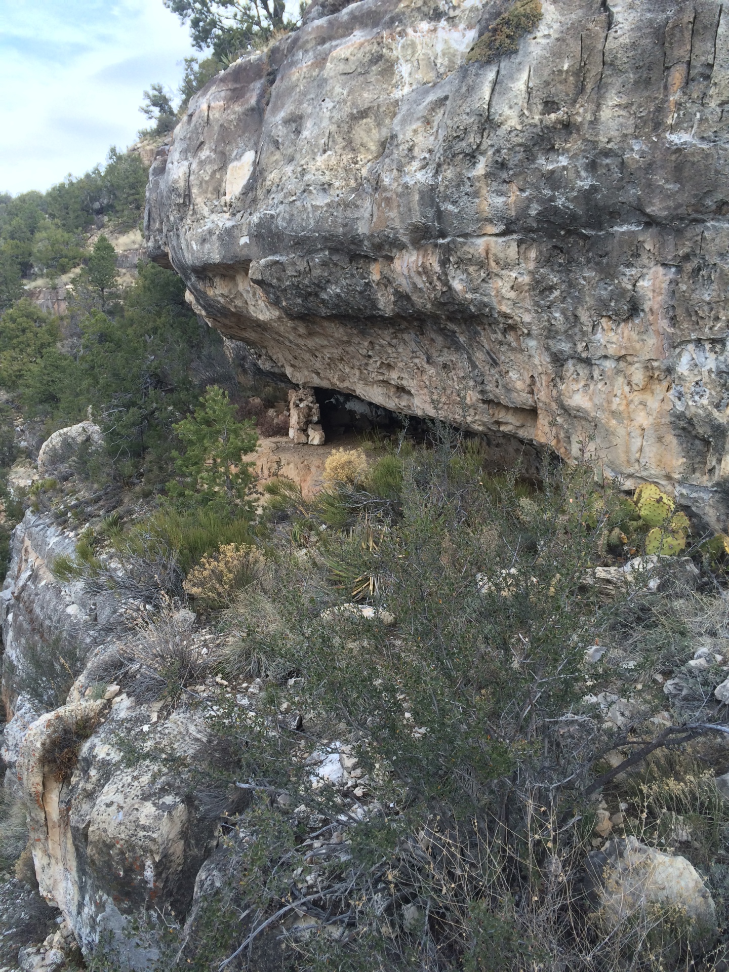
History: Perhaps the most remote and dramatic ruin in the state belongs to the ancient Anasazis. Their most famous ruin lies in Mesa Verde National Park, one of the most intricate and well-preserved ruins in the world. Keet Seel, although smaller, is no less a feat of engineering and imagination. Built into the Navajo Sandstone’s towering red cliffs, the ruin contains several structures with multiple rooms, evidence of irrigation, farming, trade, and a thriving community that likely was home to roughly 150 indigenous peoples at any given time. Research suggests that this pueblo was inhabited for only about 50 years before being abandoned. The abandonment coincided with what archaeologists and anthropologists refer to as “The Great Drought” that was the likely cause of a steady decline and exodus of the indigenous population in the region.
Location:Northeast of Kayenta in Tsegi Canyon of the Navajo Nation. It requires an 8.5-mile hike, and permits are required.
Geologically, all of these ruins share similar characteristics; they are located on or near groundwater springs, and in areas that are either high vantage points or masked by canyon walls. Before our modern abilities to bulldoze rock formations and create vast waterways through engineering and excavation, these people used geology and topography to pick and choose their homes. They worked with the land to build impressive, ingenious, and flourishing societies that rivaled the largest civilizations of their day, and created sustainable living in an arid, hostile climate and landscape.
Though their current absence indicates a lack of total sustainability, it is hard to imagine building any society that is sustainable in perpetuity, being impervious to drought, volcanoes, disease, war, famine, etc. Certainly our cities and culture as a whole are not impervious to these kind of disasters. Although we may be more technologically advanced and able to handle rapidly changing conditions, we by no means have created a more sustainable society.
To see these ruins up close is to transport yourself back hundreds of years and vicariously live in a simple world devoid of iPhones, social media, selfies, and embraces our natural world in peace and harmony. Cheers!
May The Goat be always with you
by The Goat | Mar 12, 2020 | Ancient Ruins, Cultural History, Uncategorized
Not Simply Ruins, but Spectacular Cliff and Canyon Living
What makes many of Arizona’s ruins so intriguing is that their building styles flow so gracefully with the geology and topography of the chosen settlement site. Nowhere is this more on display than in Walnut Canyon National Monument near Flagstaff, AZ. These ruins, inhabited between 1150 and 1250 AD by the Sinagua people, are built directly into the sheer canyon walls. Utilizing overhangs in the Kaibab Limestone, products of millions of years of erosion, The Sinagua (translated as “without water”) built a flourishing society of several hundred people, with livestock, crops, and trade with a network of other Puebloans in the region.
Dwellings using “islands”, or overhangs in the limestone
From these positions in the canyon, the tribe could see, hear, and observe everything around them. The settlement was easily defended using this building technique, and the tribe could easily send goods through the network of foot trails, as well as relay messages with signals across the canyon. Any enemy thinking of attacking this settlement would have been well-advised to look for softer targets, as launching an attack against this settlement would have almost certainly resulted in an embarrassing defeat.
The settlements’ clandestine location also worked in its favor. In contrast to the Walnut Canyon Ruins, the Wupatki Ruins roughly 10 miles to the north, also utilized by Sinagua, but mostly Anasazi people, is perched on a mesa, visible for tens of miles in all directions. What makes each of these settlements so unique is their geographic contrast, one on a mesa to see who is coming, and one in a canyon to make sure nobody sees them.
These thought processes, not only in stark contrast to each other, but are in polar contrast to our modern way of “settlement” building. We build for convenience, aesthetics, and capital gain. We pay no mind to sourcing local material, available water and food sources, trade proximity, or settlement defense. These were all important factors in these ancient dwellings that determined the sustainability of the settlement.
Though these settlements were primitive, it does make one wonder about the cyclical nature of human existence, as these dwellings wer built long after powerful and technologically advanced civilizations had come and gone such as the Greeks, Roman, Aztecs, and Mayans. Will our species one day return to this primitive style of living? Only time will tell. Geologic time that is….
by The Goat | Mar 12, 2020 | Geology, Hiking
Ubiquitous Lava Flows turn to Thundering Cascades
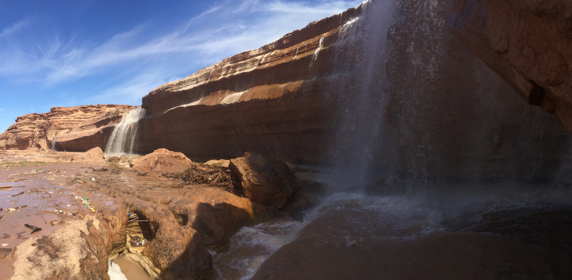
This past weekend provided The Goat an excellent opportunity to explore one of the hidden gems of the Painted Desert, simply known as Grand Falls. Tucked into a canyon carved by the Little Colorado River on Navajo Nation, the falls are taller than Niagara Falls, and when flowing at full strength (which they were not upon The Goat’s visit) can exceed more than 2000 cf/s, more than Yosemite and Nevada Falls combined.
The best time to visit this gem is in early March during the spring melt in the White Mountains, after a strong summer monsoon, or anytime the flows exceed 700 cf/s. When flowing at capacity, it is obvious why the falls have earned their loving moniker “chocolate falls”, as the sediment-laden river takes on the appearance of flowing chocolate milk reminiscent of Mr. Wonka’s factory.
No permit is necessary to visit, and it is a relatively easy, although somewhat steep hike down from the ridge. From inside the beast, one can view just how these falls came to be when a lava flow emanating from a nearby cinder cone blocked the river, forcing it to change course and cascade down the Kaibab limestone cliffs.
If you find yourself in our playground on a weekend in the spring, we highly recommend taking a look at something very rare in our state: flowing water!
For trips to Grand Falls and through geologic time come with us
by The Goat | Mar 12, 2020 | Hiking
Inspired by my latest trip up a 12,000ft Mountain
Illuminate, appreciate, breathe deeply
Smell of strong coffee wafting
Silent contemplation, sipping cool air and hot liquid
Time stays timeless, one foot in front of another
White Aspen cut the Black Darkness, standing sentinel
pink, purple, blue streaks painted by the unseen sun as the stars give way
Mind sharpening, senses dulling, come back
Jagged rocks, dampening socks, ropes through belays
Fear is my companion, Adrenaline is my mistress
False, always another, always over the horizon
Listen, look, sun above me, clouds below me, a vast canvas stretching
Muscles aching, mind longing, heart pounding, feet never stop
Looking back to see the beast
Something accomplished, to say the least
Every day will now feel sweeter
Every moment will pass completer
Do not relent, Do not give in
Until the mountain calls from within
This poem was constructed as the crew and a few of our beloved guests climbed Humphrey’s Peak, the high point in the state of Arizona at 12,635ft above sea level. As a former volcano, it is one of the more strenuous, rewarding climbs one can do in our beautiful state. We hope you enjoyed The Goat’s original work, and we hope that it inspires you to climb your own mountain!
May The Goat be always with you
by The Goat | Mar 12, 2020 | Geology, Hiking, Rock Talks
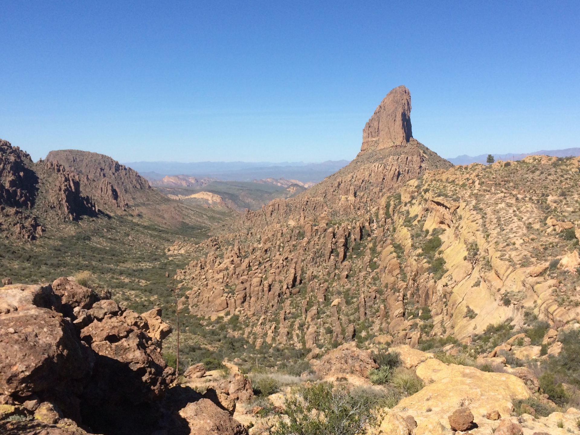
Arizona’s Superstition Mountains: Lost Gold and Sweet Hiking
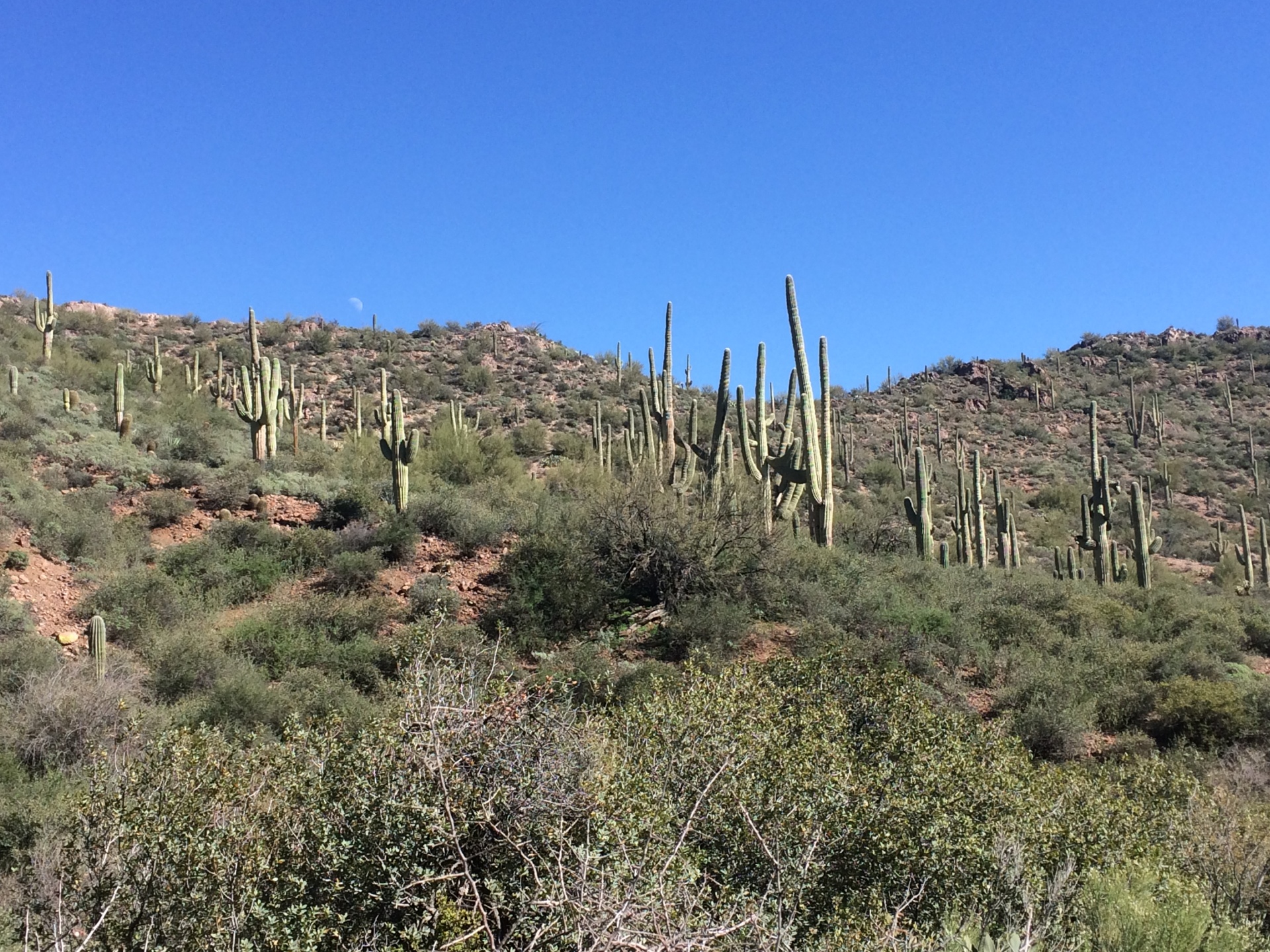
Celebrated as perhaps the premier wilderness area within an hour of a metropolitan area, the Superstition Mountains boast flawless beauty, fabulous geology, and epic hiking and adventure opportunity. However, their most supreme treasures lie in legend, alluring, mysterious, and intriguing legend that beg of exploration both physical and mental.
Here in these mountains lies potentially the most wealthy, vast, and extraordinary mining discovery in Arizona (and perhaps the entire Old West), which of course was legendary in and of itself for the mining discoveries that led to the rapid Western Expansion of the mid-to-late 1800’s. This legend entwines geology and mystery, and just may be the West’s final and greatest secret: The Lost Dutchman Gold Mine.
History of the Superstition Mountains
Situated northeast of present-day Phoenix, the Superstition Mountains have long offered respite, shelter, and resources to those looking. Long before the herds of European settlers headed west, many of them streaming into southwest’s boomtowns of lore such as Tombstone, Bisbee, Jerome, and Goldfield, the Hohokam and Salado Puebloans inhabited the area 10,000 to 12,000 years ago, farming, trading, hunting, and building the water canals that laid the framework for 20th century Phoenicians.
After their as-of-yet unexplained migration or disappearance from the region, the Sonoran Desert saw many generations of explorers, prospectors, and Native American tribes pass through. The Spanish, led by Marcos de Niza, passed through here in search of riches and the promised-land in the early late 16th and 17th centuries.
Their descendants in the newly independent Mexico roamed the land thereafter, trading and prospering with the newly-founded United States of America in the late 1700’s when Arizona was officially part of Mexico.
Settlers of the Superstition Mountains
After the Mexican-American War and the Gadsden Purchase of 1848, Arizona became part of the United States, and along with it the beautiful Superstition Mountains. The Superstitions, however, remained fiercely-guarded Apache Territory until Geronimo’s surrender in 1886, though some rugged individuals did make this area their home.
Among these rugged individuals was a man named Jakob Waltz, a German immigrant who had prospected all over the west including California and several areas of Arizona such as Prescott, where he was documented in various census reports.
He claimed a homestead north of the Salt River in 1868, and according to folks in the area, prospected almost daily in the area until the great Phoenix flood of 1891 drove him from his land. He died that same year in the home of a close friend, to whom he is said to have divulged the location of a gold mine, the likes of which nobody had ever seen.
The location, given in riddle-like clues, has attracted treasure-hunters and dreamers for over a century now, and the legend of the Lost Dutchman Gold Mine is as popular a story as it has ever been among those who love this wonderful area.
How did the Superstition Mountains form?
Geologically-speaking, the Superstition Mountains are evidence of a monstrous volcanic explosion that took place roughly 30 million years ago. What we (geologists) typically find in this area are welded tuffs (compacted volcanic ash).
The tuff found in the Superstitions indicates a gas content that could only occur in the most violent of eruptions, and the level of welding in the tuff backs this up with the temperatures that would have to be necessary to create this kind of rock.
Long story short, the eruption that created this fantastically scenic landscape is, in geologic terms, not a place where one would typically expect a gold mine of any kind to be present, much less one that produces the kind of ore that Mr. Waltz purported to have stashed here.
More Rock Talks
New studies indicate that an intrusive batholith may underlie the Superstitions, and intrusions are where gold, silver, copper, and other valuable ores are typically located, as they are formed in the hydrothermal activity that is prevalent in these intrusions (magma cooling underground close to the surface, i.e. granite).
So, it may be possible that Mr. Waltz’s bonanza is the product of this intrusion, and therefore deep underground that ban be accessed only by cave or canyon. This location is belied by some of the cryptic clues he gave to his friend on his deathbed, so the legend may yet be true.
Indeed, the resurrected ghost town of Goldfield just 20 miles to the west of the Superstition Mountains known the west over for its high-grade gold ore, was a place where gold was discovered, mined, and profited from. Goldfield is geologic proof that gold does, in fact, exist in the general area even though the play petered out quite quickly.
The Lost Dutchman’s Gold Mine
There are many questions that still exist as to the Lost Dutchman’s Gold Mine: namely, where is it? Did it really exist? Was it simply a story to promote tourism in the area, of which Mr. Waltz’s friends certainly profited by? If Jakob Waltz’s gold was real, and some have testified that it certainly is, was it mined?
Or perhaps was it the lost stash of the Peralta family, before they were massacred by Apaches? Maybe is was an Apache stash before they were massacred by miners?
Evidence may suggest that either the Peraltas, a Mexican family for which a trail in the Superstition Wilderness is named, or the Apaches had struck bonanza gold just four miles from present-day Apache Junction, then hid it deep in the Superstition Mountains before they met an untimely end.
Whatever the real story, the legend of The Lost Dutchman Gold Mine and the Superstition Mountains attract thousands of curious visitors, avid hikers, and metaphorical treasure hunters year after year. Just to be in this outstanding wilderness area is to be surrounded by beauty, mystery, history, and the geology that is the foundation for it all.
Call us for more information about hiking in the Superstition Mountains, or enjoy this wilderness with one of our outstanding geologist/guides who will take you to the secret spots and let you in on the wondrous mysteries that surround the fabulous Superstition Mountains!
May The Goat be always with you