How was The Wave Formed?
Hiking on the Colorado Plateau is a constant game of “how did this get here?” and “why does this look this way?”. Everywhere a hiker looks, they are confronted with wild rock formations, howling desert wilderness, and geology on a nearly incomprehensible scale. The mere presence of this place has led countless professional geologists and outdoor enthusiasts alike to spend lifetimes exploring the fabulous scenery and enormous scale. From Grand Canyon to The Arches, from Antelope Canyon to The Subway in Zion, the Colorado Plateau contains some of the most fantastic and intense scenery in the world.
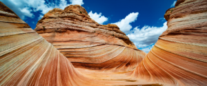
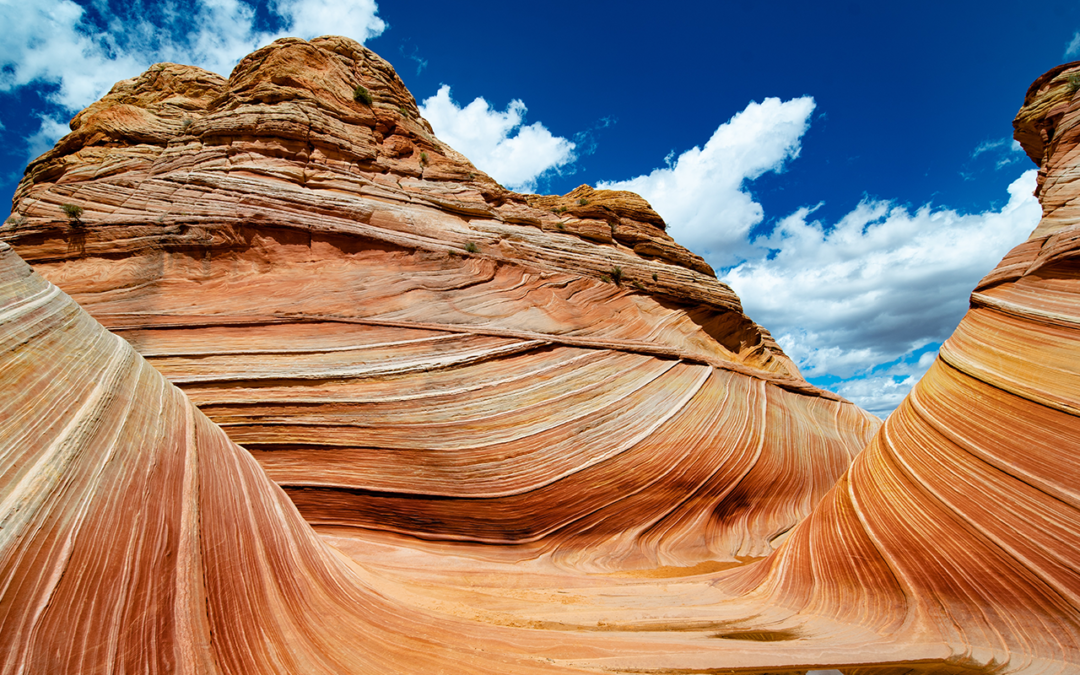
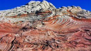
The Wave, in all of its glory
The Wave, however, is perhaps the single most-famous stand-alone feature in this wild landscape. Of course, the most often-asked question about The Wave (besides maybe how do I get a permit) is how was The Wave formed? The short answer: geology. The long answer, and the much more interesting one, begins nearly 200 million years ago. Let’s go time traveling!
The Jurassic: Wind-blown Sand Seas
The time is 180 million years ago. The place is at the southwestern margin of the supercontinent Pangea. All of Earth’s tectonic plates have assembled themselves into one, massive block of puzzle pieces. Dinosaurs roamed the landscape, but if you were standing here at the time, you would see very few living things. Here, you scramble to the top of 100 foot-high mountain of sand and gaze out over an unforgiving, desolate, and stark landscape. This is the birthplace of The Wave.
The landscape before you is thought to be the largest sand-dune desert in the history of the Earth, stretching hundreds of miles in each direction, from the ancient Pacific ocean in the west to modern-day New Mexico in the east; from modern-day Mexico in the south to what is now Wyoming in the north. Outside of the occasional desert oasis, this is a lifeless, hostile place. Trade winds blow massive amounts of sediment from the eroding Ancentral Rocky Mountains and the rising Appalachian Mountains southwest towards the ocean, forming monstrous sand dunes that migrate across the landscape like a giant game of Pac-Man, with dunes piling onto and devouring each other in the relentless winds.
As you stand upon this giant dune and wonder what is to become, you step into your time machine. Closing the door and making sure the windows are squeaky clean for maximum viewing, you begin your journey over the next 180 million years. Buckle up!
Burial, Cementing, and Uplift
Through your windows, you witness the close of the Jurassic, and the beginning of the Cretaceous. The climate cools and becomes wetter, ushering in a gradual but stark change in the environment. The Cretaceous Interior Seaway encroaches upon the land as the tectonic plates continue to shift, slowly breaking apart as Pangea slowly morphs into the modern map. The former sand dune upon which you stood sinks into the landscape and is buried by a warm sea bordered by humid swamps and yet more dunes.
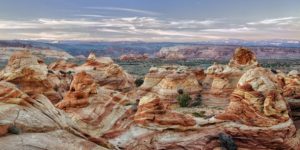
Panorama of scenes in the Vermillion Cliffs
To the west, the Pacific Tectonic plate pushes its neighbor, the Farallon Plate, under the North American Plate at a very low angle, giving rise to the Laramide Orogeny and modern-day Rocky Mountains. This uplift carries away the seas, and sets the stage for the modern landscape to emerge. In the distance, you see an intensely bright light in the sky, followed by an impact that is felt around the globe. An asteroid has pounded the Earth in what is now the Gulf of Mexico, ending the reign of the dinosaurs and the Cretaceous.
Oh, there is just one more thing….
The canvas upon which the landscape seen in photographs today is set for the artist of geologic time; erosion. However, before the final masterpiece is created there is one more incredibly important thing that must occur: the unique uplift of what will become the Colorado Plateau. As the Farallon Plate sinks into the mantle, it behaves in a peculiar manner. Typically, tectonic plates behave in a ductile manner as they are heated, flexing in a pliable way as they are resorbed into the mantle.
However, the Farallon Plate behaves in no such way. Instead of acting in a ductile manner, it behaves in a rigid, brittle manner; perhaps due to the low angle of subduction. A large piece breaks away from the whole, becomes buoyant, and is thrust back towards the surface. This piece of plate forces the surface above it to rise several thousand feet above sea level, and causes land to the west to begin extending back out to the west over the Pacific Plate. Here, on this uplifted and exposed surface is where the masterpiece will be painted.
Wind, Water, and Time
At this point, The landscape seems relatively flat and featureless. The Rockies loom on the eastern horizon, but the familiar modern landscape is buried under millions of years and thousands of feet of sediment accumulation. After all, the Navajo Sandstone is but one geologic unit and one small snapshot in time in a region that has been built quite literally one grain of sand/clay/lime at a time over nearly 550 million years.
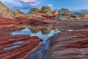
White Pockets, another wild landscape near The Wave in the Vermillion Cliffs
But, the stage has been set. The time has come. The sediment is deposited. The uplift has exposed it to the elements. Now the combined forces of wind, water, and time take their turn. We are in the Neogene period, about 20 million years ago. The Neogene period itself is not well represented by sediments or deposition on the Colorado Plateau.
Therefore, it is difficult to say precisely what environmental conditions existed. However, what we can say for certain is that, beginning in the Neogene, the Colorado Plateau began to undergo a sustained and intense period of erosion and deep dissection. This period continues to this day as the high plateau is exposed daily to the ravages of winds, pulsated by short periods of intense precipitation (rain and snowstorms). In addition, the general conditions of the desert make this place quite inhospitable to large and widespread plant life. This helps foster the erosive forces carving into the rocks, and leaves them uncovered for all to view in their splendor. Yay for us!
Okay, great. Get to the point!
You came here to know how The Wave was formed. Let’s talk about that! As discussed, numerous specific things had to occur for this feature to be created. All of those things have now happened, and we are ready to form The Wave. Strip away the overlying sediments, down into the sleeping Navajo Sandstone. Neogene period, got it. 15-20 million years ago, check. Erosion, check. But this feature, specifically?
The nature of the Navajo Sandstone in Vermillion Cliffs
The Wave is the specific result of small trickles of water contouring their ways through the Navajo Sandstone, followed by long, sustained periods of wind. As we discussed, prior to deep dissection the area was a flat-ish, blank canvas. During periods of rain, water follows the path of least resistance due to gravity. This feature of water allows it to create “nickpoints”, or places that are routinely exposed to water flows and erode faster than areas where water does not flow. Yep, this all checks out. So what?
The Formation of The Wave
So what, you say? This is what. The Wave’s appearance began very carefully with small trickles of water cutting into one particular “nickpoint”. After water carved the niche, wind took over. From that small nickpoint, the wind howled though relentlessly over the many millions of years afterwards (15+ million). Punctuated by alternating winds and small trickles of water, The Wave was carefully and painstakingly carved from the sandstone. Surf’s up!
That’s how the feature itself was formed. A deeper question is this: why does it look this way? (with the waviness and lines?). Elementary, my Dear Watson! The Navajo Sandstone, of course! You see, as we’ve discussed, the Navajo Sandstone was deposited as large sand dunes. Sand dunes are formed by layers of sand piling upon one another, then avalanching down the front face as the dune migrates. The avalanches and migrations are preserved as wavy lines, revealing the internal structure of the dune. It is known in geologic terms as “planar-tabular cross bedding”.
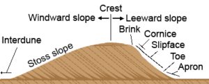
Diagram of the formation of sand dunes, courtesy smallpond.ca
In effect, the dunes are waves, just made of sand instead of water. Therefore, The Wave is truly a “wave”; petrified waves of stone.
The Future of The Wave
The geologic processes that formed The Wave are, ironically, the same that will destroy it. Current geologic processes are exposing the Colorado Plateau to erosion. These processes are likely to continue into the near-term (several million years) geologic future barring some catastrophic event or sequence of events.
However, you can rest easy knowing that The Wave, along with most of our favorite features in canyon country are here to stay for the foreseeable human future. Enjoy!
Going Guided
Although it is possible to see these places yourself, hiring a guiding outfitter is a great idea. For instance, guiding services provide logistical support, and plan everything for your best possible trip. They provide a great safety net on the trail, and are trained in backcountry medicine. Above all, they provide a depth of knowledge of the region that turns a walk into a true adventure.
**Remember, you cannot hike or visit The Wave without a permit! Getting caught without a permit is a bad situation.**
Canyons and Chefs provides all of the support you need, and pairs that with professional chefs and expert geologist/guides. Our meals use fresh ingredients and are inspired by local farms, culture, and cuisine. We utilize a mobile professional kitchen as a backbone for cooking over the fire. Furthermore, we provide top-of-the-line gear and passion for the places we explore. In conclusion, you can see these wild places, but going with an outfitter can create an even more memorable experience. Don’t be shy, and call us!
Read our blog!
For adventure Chef-Driven Outdoor Experiences, see our epic tours in Grand Canyon, Utah, and Arizona!
Follow us on Facebook and Instagram
Explore Further, Be Wild, Eat Like Kings —
Canyons and Chefs