Hiking Red Mountain near Flagstaff, Arizona
Red Mountain —
Exposed Interior of a Volcano
Introduction
Welcome to Flagstaff, the land of towing pines, golden-leafed aspens, and ancient volcanoes. Today you will have the pleasure of visiting Red Mountain, one fo the most scenic and interesting hikes in the area, and a treasure trove of geology, history, and scenery. Enjoy, and don’t forget to give Canyons and Chefs a shout on a Google review.
How do I get there?
Getting here is quite simple, scenic, and about a 25-minute drive from downtown Flagstaff. You will travel through large stands of old-growth ponderosa forest and the towering mountains of the San Francisco Volcanic Field. These mountains dominate the skyline of Flagstaff, and are well-known as the tallest mountains in Arizona.
After you pass Snowbowl Road and break through the trees, be sure to look out your window to catch a glimpse of Humphrey’s Peak, Arizona’s loftiest peak at 12,635 feet. Humphrey’s summit is quite inauspicious, as it is just the simple crested hump on the most-northern side of the peak complex. Continue on your journey.
From downtown, head north to HWY 180 (Fort Valley Rd). Continue on HWY 180, then turn left at at mile marker 247 and forest road 9023V the signed junction for Red Mountain. You will can see Red Mountain looming over the landscape from the road. Take the easy dirt road for about 0.25 mile before parking in the designated lot. Enjoy!
What should I bring?
For all hikes in Flagstaff, it is wise to be prepared for the weather to change, sometimes very quickly. Locals say “if you don’t like the weather, just wait five minutes”. There is often wind, especially in the spring, and rain/snowstorms can occur at any time, sometimes without much warning. Wear sturdy shoes (no open toes, sandals, or flip-flops), and as always avoid cotton or denim.
For this hike I also strongly advise bringing a camera (phone is fine) and geologist’s hand lens. You may purchase one here, or they can be found at most jewelry stores (they are also known as jewelers loupes), hardware stores (HomCo in Flagstaff) is great place, or online.
For a full checklist of what to bring on any hike, check out The Goat’s Day Hiking Essentials.
The History of the Landscape
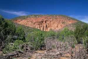
Red Mountain is what is known as a “cinder cone”, which is essentially a dwarf volcano. These features, which dot the landscape of the San Francisco Volcanic Field, typically lie along fault lines, or fractures in the crust. Magma pushes through the crustal weakness creating a bulge in the landscape, and extrudes onto the surface as basaltic lava. The lava bubbles and flows over the landscape in pulses, building up one pulse after another to form a dome, or cinder cone.
Beginning about 4 million years ago, widespread volcanic activity started in earnest in this region that is now known as the southern portion of the Colorado Plateau. The landscape is dotted with thousands of features born from magma, lava, and the ever-churning molten interior of the Earth. Among these are the aforementioned San Francisco Peaks that graced your window view on the way here, lava tubes and caves, and of course cinder cones.
The Mountains Rise….
The San Francisco Volcanic Field rose as part of the massive tectonic forces that are responsible for the Colorado Plateau and its neighboring geologic province known as the Basin and Range. The Plateau hosts features such as deep canyons and intricate erosional features, while the Basin and Range is punctuated by isolated mountain ranges spaced by isolated basins.
The large, saucer-shaped uplift that is the Colorado Plateau is a relatively stable tectonic area, while the Basin and Range is the product of extension, or tectonic movement that results in “stretching”. The Basin and Range is pulling away from the Colorado Plateau like Silly Putty, and that is the action responsible for the San Francisco Volcanic Field. As the crust stretches, magma from the subsurface is able to penetrate upwards, leaving its signatures behind.
Volcanoes and Such
The San Francisco Peaks form what once was part of a singular massive volcano standing roughly 16,000 feet tall, the main feature in the area. The extensional tectonics pulling the Basin and Range resulted in several periods of volcanism of varying intensities at the southern margin of the Plateau, forming the features surrounding you. On the most intense scales, volcanic activity created the massive mountain that ultimately erupted catastrophically, blowing its top and collapsing in on itself.
On the less intense spectrum, the volcanism created thousands of smaller features; among them are the cinder cones that surround the massive caldera known as the San Francisco Peaks. Red Mountain is one of these cinder cones. Roughly 740,000 years ago, myriad pulses of volcanic activity produced basaltic lava that extruded, or flowed, out onto the surface.
These eruptions included several types of pyroclastic (stuff from volcanoes, simply put) ejecta such as cinders, bombs, and ash in addition to the lava. Layers hardened, only to be covered by subsequent flows and eruptions. Over and again, the lavas flowed and hardened, building Red Mountain into the classic cinder dome shape.
Collapse and Dissection
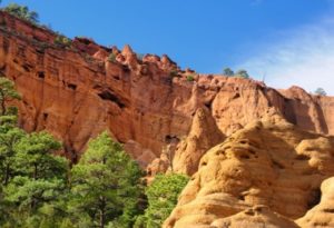
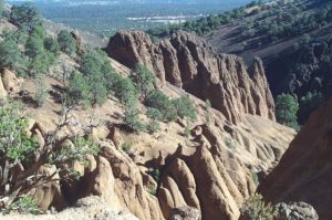
Through the wonderful forces of erosion, the Red Mountain cinder cone has been excavated and exposed. Faulting along the same lines that created the cinder cone are also responsible for the collapse of the eastern side. This collapse allowed for rain, snow, frost, and wind to take a scalpel over the several hundred thousand years after.
The amphitheater that has been created provides an inside-out look at this volcanic structure, giving geologists tremendous insight into their formation processes. Contained within Red Mountain is a fairyland of spires, hoodoos, and cliffs carved out by the forces of water, wind, and time.
Cultural History
Although there is little evidence of prolonged habitation in and around Red Mountain, the greater area was host to generations of Ancestral Puebloan Tribes. The most prominent tribe in the area are known as the Sinagua People, or “the people without water”. They are known as such given the dry conditions under which they lived, with few perennial water sources.
These peoples farmed, hunted, and traded in the area beginning around 1500 years ago before moving on around 850 years ago. The eruption of the Sunset Caldera around 960 years ago is surmised to be the main reason for their disappearance. The remnants of their once-flourishing society can be observed in Sunset-Wupatki National Monument, where they’ve left large, well-preserved structures on the rolling hillsides, and Walnut Canyon National Monument where structures have been built into the cliffs of the canyon itself.
Hiking Red Mountain near Flagstaff
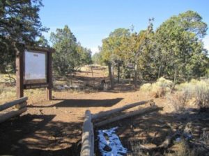
The hike here is more of a leisurely, scenic stroll, just one mile to the interior of the amphitheater. The trail is well-worn and easy to follow. Begin from the signed trailhead at the edge of the parking lot.
Point of Interest #1
At .75 mile, you will come to a small, dam-looking apparatus. Stop and look down in the sand. The unconsolidated material underfoot is known as alluvium, or material deposited by water. Upon closer inspection, you will see black material that glints in the sun. Pick it up. This is the mineral known as hornblende, which is a member of the amphibole family. Hornblende is an associate mineral of basalt, the type of lava that extruded from this cinder cone. If you have brought a geologic hand lens, inspect the specimen closely. Take note of its habit (the character of its form), its cleavage (the way the mineral breaks or fractures), and its hardness (how hard it is; the best way to test this is to scratch it on another rock).
You are now being a geologist! This is how geologists make determinations about what kind of mineral they are observing out in the field. Mineralogy is an important tool for any geologist, as it allows us to make inferences about the type of rocks that are present, and most importantly, under what type of conditions they formed. In this case, we know that the mineral horblende forms in the upper mantle under particular sets of pressure and temperature conditions. This allows us to delve deeply into the history of this magma, and pinpoint exactly where it came from. Hooray!
From here, take the small ladder or scramble up the right side of the structure. Watch your footing, loose cinder can act like ball bearings under your feet!
Point of Interest #2
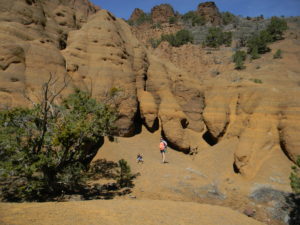
At 1.0 mile, you have reached the main attraction! You are now in the amphitheater of the Red Mountain Cinder Cone. Take stock of what you see. The landscape reveals a fairyland of carefully-sculpted pinnacles, and forms known as hoodoos. The sunset red-orange is set brilliantly against the deep green of the surrounding ponderosa pines, adding a wonderful contrast of color to the beautiful scenery. Examine the hoodoos. You can tell the difference between a hoodoo and a pinnacle by its formation mechanism. The hoodoos are protected by a caprock, or harder rock on top of softer rock.
The harder rock protects the soft stuff below it from erosion, over time forming the hoodoo. Though it is more difficult to see without serious inspection, the pinnacles form along joints, or weaknesses in the rock as a whole. Mapping joints and fractures can be a very complex task! Take our your hand lens and inspect a caprock that tops a hoodoo. You will again see the mineral hornblende, but this time you will also be able to observe the mineral feldspar (the little whitish flecks), the mineral pyroxene (more black, tough to distinguish from hornblende), and olivine (green, a common mineral in basalt).
Point of Interest #3
Explore deeper into the walls of the amphitheater. Look up. Observe the bedding features present in the walls. You will notice the horizontal layers, which are bedding planes, and the tilted nature of the overall bedding. Go up close to the walls and look closely at the bedding planes. Contained within these structures is massive amounts of information helpful to a geologist. Notice the thickness of each layer.
This will tell you the volume of the eruptive pulse. Observe what is contained within the beds, feel with you hands. You will observe layers of consolidated rock, the basalt, fine layers of what looks like blonde sand )the ash), and small chunks of basalt mixed with ash; evidence of more violent eruptive pulses. Sweet!
Point of Interest #4
Continue to observe the nature of the bedding. You will undoubtedly notice a tilting toward you of the bedding planes. This is what geologists call dip, or bedding attitude. The degree of bedding is very helpful in understanding formational processes.
In this case, the bedding dipping toward you is a good clue the the actual center, or caldera, of the volcano is not actually in the amphitheater center, but on the other side of the walls. The radial nature also gives away another important clue; wind presence and direction during periods of eruption.
Low or no wind presence will allow for a symmetrical structure, while sustained or high winds will result in an asymmetrical formation. You may notice that the bedding planes seem to “lean” to the north, or to the right of where you stand. This tells you that the wind was a-blowin’, which gives us ideas about the natural environment at this time in geologic history.
The walls also hold other clues to the formation of this feature. You may observe holes in the upper reaches. These are dissolution features, oftentimes remnant of hydrothermal activity (hot water moving through the subsurface). This activity may have played an important part in the tearing and subsequent erosion of this cinder cone.
Most cones are consolidated, and therefore not observable from the inside. But the collapse of the side of Red Mountain has provided a spectacular look into its anatomy. It is highly likely that faulting along the Mesa Butte Fault, whose trace is essentially right under your feet, produced superheated water that dissolved the feature from the inside, leading to its collapse.
Point of Interest #5
Take a moment to quiet your body and mind to revel in the silence, sunlight, and beauty. Oftentimes the high walls and ledges are great nesting grounds for Peregrine Falcons, Red-Tailed Hawks, and even Bald Eagles. Watch for them swooping in the mid-day or evenings, and listen for their bird-of-prey screeches, much different from the average songbird!
When you are finished enjoying the natural beauty, scenery, solitude, and quiet, turn and follow the path the way you came.
What’s for Lunch?
Chef’s Selection of Cheeses
Chef’s Selection of Charcuterie
Fresh-Baked Crusty Bread
House-Smoked Atlantic Salmon – Salmon is from Randal’s Fine Meats
Chef’s Fresh-Squeezed Juice of the Moment
Chef’s Selection of Wine from the Cellar
Going Guided
Hiking and exploring The Wave, or any of our public lands, is a special experience. Although it is possible to see these places yourself, hiring a guiding outfitter is a great idea. For instance, guiding services provide logistical support, and plan everything for your best possible trip. They provide a great safety net on the trail, and are trained in backcountry medicine. Above all, they provide a depth of knowledge of the region that turns a walk into a true adventure.
Canyons and Chefs provides all of the support you need, and pairs that with professional chefs and expert geologist/guides. Our meals use fresh ingredients and are inspired by local farms, culture, and cuisine. We utilize a mobile professional kitchen as a backbone for cooking over the fire. Furthermore, we provide top-of-the-line gear and passion for the places we explore. In conclusion, you can explore these wild places, but going with an outfitter can create an even more memorable experience. Don’t be shy, and call us!
Read our blog!
For adventure Chef-Driven Outdoor Experiences, see our epic tours in Grand Canyon, Utah, and Arizona!
Follow us on Facebook and Instagram
Explore Further, Be Wild, Eat Like Kings —
Canyons and Chefs