by The Goat | Mar 23, 2020 | Geology, The Wave, Vermillion Cliffs
How was The Wave Formed?
Hiking on the Colorado Plateau is a constant game of “how did this get here?” and “why does this look this way?”. Everywhere a hiker looks, they are confronted with wild rock formations, howling desert wilderness, and geology on a nearly incomprehensible scale. The mere presence of this place has led countless professional geologists and outdoor enthusiasts alike to spend lifetimes exploring the fabulous scenery and enormous scale. From Grand Canyon to The Arches, from Antelope Canyon to The Subway in Zion, the Colorado Plateau contains some of the most fantastic and intense scenery in the world.
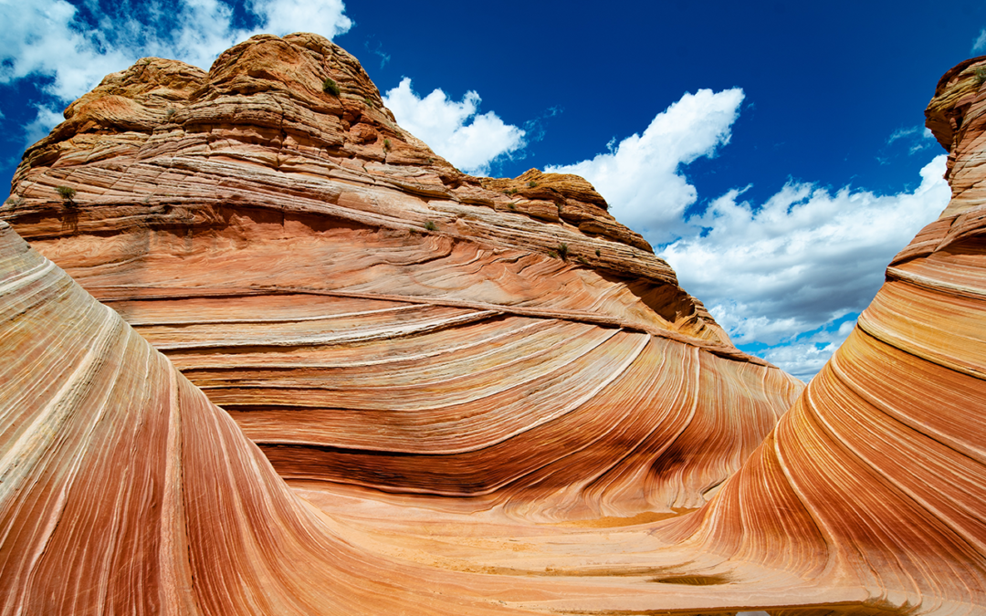
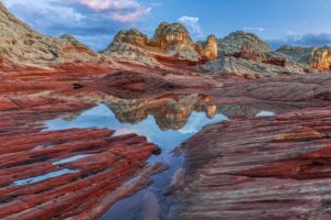
The Wave, in all of its glory
The Wave, however, is perhaps the single most-famous stand-alone feature in this wild landscape. Of course, the most often-asked question about The Wave (besides maybe how do I get a permit) is how was The Wave formed? The short answer: geology. The long answer, and the much more interesting one, begins nearly 200 million years ago. Let’s go time traveling!
The Jurassic: Wind-blown Sand Seas
The time is 180 million years ago. The place is at the southwestern margin of the supercontinent Pangea. All of Earth’s tectonic plates have assembled themselves into one, massive block of puzzle pieces. Dinosaurs roamed the landscape, but if you were standing here at the time, you would see very few living things. Here, you scramble to the top of 100 foot-high mountain of sand and gaze out over an unforgiving, desolate, and stark landscape. This is the birthplace of The Wave.
The landscape before you is thought to be the largest sand-dune desert in the history of the Earth, stretching hundreds of miles in each direction, from the ancient Pacific ocean in the west to modern-day New Mexico in the east; from modern-day Mexico in the south to what is now Wyoming in the north. Outside of the occasional desert oasis, this is a lifeless, hostile place. Trade winds blow massive amounts of sediment from the eroding Ancentral Rocky Mountains and the rising Appalachian Mountains southwest towards the ocean, forming monstrous sand dunes that migrate across the landscape like a giant game of Pac-Man, with dunes piling onto and devouring each other in the relentless winds.
As you stand upon this giant dune and wonder what is to become, you step into your time machine. Closing the door and making sure the windows are squeaky clean for maximum viewing, you begin your journey over the next 180 million years. Buckle up!
Burial, Cementing, and Uplift
Through your windows, you witness the close of the Jurassic, and the beginning of the Cretaceous. The climate cools and becomes wetter, ushering in a gradual but stark change in the environment. The Cretaceous Interior Seaway encroaches upon the land as the tectonic plates continue to shift, slowly breaking apart as Pangea slowly morphs into the modern map. The former sand dune upon which you stood sinks into the landscape and is buried by a warm sea bordered by humid swamps and yet more dunes.
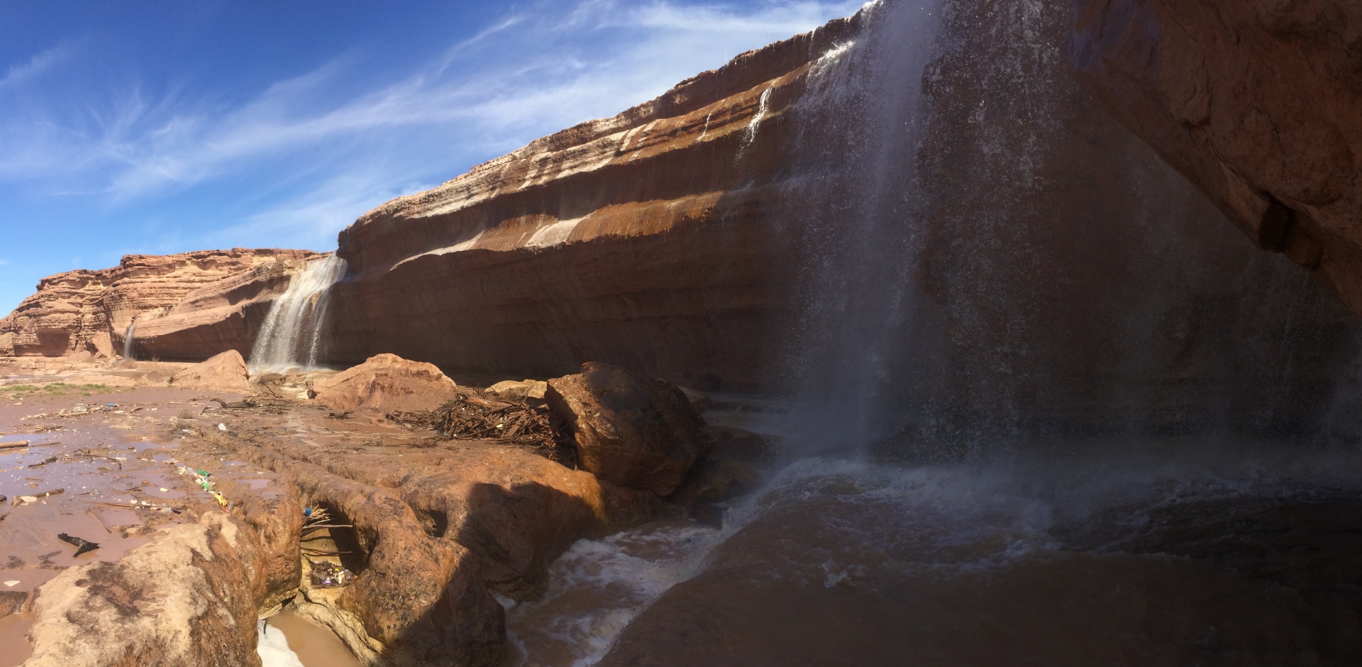
Panorama of scenes in the Vermillion Cliffs
To the west, the Pacific Tectonic plate pushes its neighbor, the Farallon Plate, under the North American Plate at a very low angle, giving rise to the Laramide Orogeny and modern-day Rocky Mountains. This uplift carries away the seas, and sets the stage for the modern landscape to emerge. In the distance, you see an intensely bright light in the sky, followed by an impact that is felt around the globe. An asteroid has pounded the Earth in what is now the Gulf of Mexico, ending the reign of the dinosaurs and the Cretaceous.
Oh, there is just one more thing….
The canvas upon which the landscape seen in photographs today is set for the artist of geologic time; erosion. However, before the final masterpiece is created there is one more incredibly important thing that must occur: the unique uplift of what will become the Colorado Plateau. As the Farallon Plate sinks into the mantle, it behaves in a peculiar manner. Typically, tectonic plates behave in a ductile manner as they are heated, flexing in a pliable way as they are resorbed into the mantle.
However, the Farallon Plate behaves in no such way. Instead of acting in a ductile manner, it behaves in a rigid, brittle manner; perhaps due to the low angle of subduction. A large piece breaks away from the whole, becomes buoyant, and is thrust back towards the surface. This piece of plate forces the surface above it to rise several thousand feet above sea level, and causes land to the west to begin extending back out to the west over the Pacific Plate. Here, on this uplifted and exposed surface is where the masterpiece will be painted.
Wind, Water, and Time
At this point, The landscape seems relatively flat and featureless. The Rockies loom on the eastern horizon, but the familiar modern landscape is buried under millions of years and thousands of feet of sediment accumulation. After all, the Navajo Sandstone is but one geologic unit and one small snapshot in time in a region that has been built quite literally one grain of sand/clay/lime at a time over nearly 550 million years.
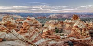
White Pockets, another wild landscape near The Wave in the Vermillion Cliffs
But, the stage has been set. The time has come. The sediment is deposited. The uplift has exposed it to the elements. Now the combined forces of wind, water, and time take their turn. We are in the Neogene period, about 20 million years ago. The Neogene period itself is not well represented by sediments or deposition on the Colorado Plateau.
Therefore, it is difficult to say precisely what environmental conditions existed. However, what we can say for certain is that, beginning in the Neogene, the Colorado Plateau began to undergo a sustained and intense period of erosion and deep dissection. This period continues to this day as the high plateau is exposed daily to the ravages of winds, pulsated by short periods of intense precipitation (rain and snowstorms). In addition, the general conditions of the desert make this place quite inhospitable to large and widespread plant life. This helps foster the erosive forces carving into the rocks, and leaves them uncovered for all to view in their splendor. Yay for us!
Okay, great. Get to the point!
You came here to know how The Wave was formed. Let’s talk about that! As discussed, numerous specific things had to occur for this feature to be created. All of those things have now happened, and we are ready to form The Wave. Strip away the overlying sediments, down into the sleeping Navajo Sandstone. Neogene period, got it. 15-20 million years ago, check. Erosion, check. But this feature, specifically?
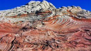
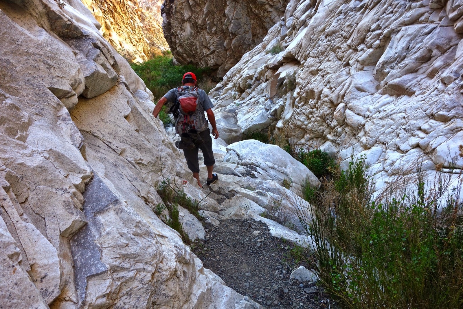
The nature of the Navajo Sandstone in Vermillion Cliffs
The Wave is the specific result of small trickles of water contouring their ways through the Navajo Sandstone, followed by long, sustained periods of wind. As we discussed, prior to deep dissection the area was a flat-ish, blank canvas. During periods of rain, water follows the path of least resistance due to gravity. This feature of water allows it to create “nickpoints”, or places that are routinely exposed to water flows and erode faster than areas where water does not flow. Yep, this all checks out. So what?
The Formation of The Wave
So what, you say? This is what. The Wave’s appearance began very carefully with small trickles of water cutting into one particular “nickpoint”. After water carved the niche, wind took over. From that small nickpoint, the wind howled though relentlessly over the many millions of years afterwards (15+ million). Punctuated by alternating winds and small trickles of water, The Wave was carefully and painstakingly carved from the sandstone. Surf’s up!
That’s how the feature itself was formed. A deeper question is this: why does it look this way? (with the waviness and lines?). Elementary, my Dear Watson! The Navajo Sandstone, of course! You see, as we’ve discussed, the Navajo Sandstone was deposited as large sand dunes. Sand dunes are formed by layers of sand piling upon one another, then avalanching down the front face as the dune migrates. The avalanches and migrations are preserved as wavy lines, revealing the internal structure of the dune. It is known in geologic terms as “planar-tabular cross bedding”.
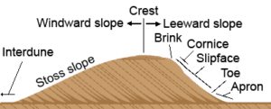
Diagram of the formation of sand dunes, courtesy smallpond.ca
In effect, the dunes are waves, just made of sand instead of water. Therefore, The Wave is truly a “wave”; petrified waves of stone.
The Future of The Wave
The geologic processes that formed The Wave are, ironically, the same that will destroy it. Current geologic processes are exposing the Colorado Plateau to erosion. These processes are likely to continue into the near-term (several million years) geologic future barring some catastrophic event or sequence of events.
However, you can rest easy knowing that The Wave, along with most of our favorite features in canyon country are here to stay for the foreseeable human future. Enjoy!
Going Guided
Hiking and exploring The Wave located in Coyote Buttes in southern Utah and northern Arizona is an incredible experience. There are few hiking trails in the southwest that come close to the sheer awe that is induced while seeing The Wave for the first time. While securing permits can be a challenging affair, it’s totally worth it. Hiking The Wave is something everyone should experience in their lifetime.
Although it is possible to see these places yourself, hiring a guiding outfitter is a great idea. For instance, guiding services provide logistical support, and plan everything for your best possible trip. They provide a great safety net on the trail, and are trained in backcountry medicine. Above all, they provide a depth of knowledge of the region that turns a walk into a true adventure.
**Remember, you cannot hike or visit The Wave without a permit! Getting caught without a permit is a bad situation.**
Canyons and Chefs provides all of the support you need, and pairs that with professional chefs and expert geologist/guides. Our meals use fresh ingredients and are inspired by local farms, culture, and cuisine. We utilize a mobile professional kitchen as a backbone for cooking over the fire. Furthermore, we provide top-of-the-line gear and passion for the places we explore. In conclusion, you can see these wild places, but going with an outfitter can create an even more memorable experience. Don’t be shy, and call us!
Read our blog!
For adventure Chef-Driven Outdoor Experiences, see our epic tours in Grand Canyon, Utah, and Arizona!
Follow us on Facebook and Instagram
Explore Further, Be Wild, Eat Like Kings —
Canyons and Chefs
by The Goat | Mar 12, 2020 | Geology, Uncategorized

Though it may seem an arbitrary question, we really cannot delve into anything else, nor even have Blue Marble Adventure GeoTourism, LLC exist without discussing something vital. What actually is geology? By dissecting the Greek roots of the name, we can gather geo (Earth) and logy (the study of something) translates literally to “the study of the Earth”. What does this mean? It seems wildly general and somewhat ridiculous.
The truth is that geology is, in fact, the comprehensive science of everything. It includes physics, chemistry, biology, and mathematics. Geologists must possess a fundamental understanding of each of these, and draw upon that knowledge along with observation to deduce an historical account of why everything looks the way that it does. To be a geologist is to be a scientist, a historian, a puzzle builder, an explorer, and a steward of the Earth and cosmos.
In its most pure form, geology is the study of rocks. Where did they come from, how did they get here, and why do they look the way they do? These are all questions that are constantly in the mind of a geologist such that an easy dayhike to anyone else is an opportunity to learn about the historical evolution of the area. Geologists examine rocks from the ground up (no pun intended) to deduce its history starting from its building blocks, the minerals within. The mineral composition, alignment, grain sizes, and various other physical and chemical characteristics can help a geologist determine what a rock is, then allows them to deduce the entire history of that rock and thereby the region from whence it came.
From these most humble of origins, geologists have begun to unravel the mysteries of the creation of the Earth some 4.6 billion years ago until now. From the accretion of the Earth to the present-day Anthropocene, the crust has rearranged itself into three different supercontinents, life begun and species have evolved, glaciers have come and gone, massive volcanoes have cataclysmically erupted, meteors have bombarded, and all of these wonderfully apocalyptic happenings have been recorded by the rocks that they created.
The answer to many of the questions as to why we are here and where we might be going is contained within the rock record waiting to be discovered. Whether you set out to discover them yourselves, or whether to go guided by us here at Blue Marble, we can answer any of the questions that may nip at your existential ankles. Ask a geologist, it will always be a great story!
Photo Courtesy of The Goat, Banded Gneiss Near Durango, CO
For More about geology and all things adventure Follow The Goat
by The Goat | Mar 12, 2020 | Geology, History
Here I am, 30km below the Earth’s surface. Patiently waiting, my kayak bobs up and down in a pool of molten magma the size of the state of Maine. I am anticipating the ride of my life, and have been waiting for nearly 600,000 years for the perfect wave. Underneath the place in which we have come to know as Yellowstone National Park, potentially the most pristine and breathtaking place on the face of the planet, lies a boiling pot that at some point in the geologically-near future will need to release its enormous energy. It is that release for which I am waiting, and the ebb and flow of building pressure is maddeningly rhythmic, enough to lull a thrill-seeker to sleep; but I know I must keep my vigilance, for when it comes it will be rapid and without warning. From my vantage point, I am aware of my relative position rising nearer and nearer to the surface, pushing up the land into nearly indiscernible domes on the surface. I rock back and forth in preparation for that moment.
I know that on the surface mud pots have begun to broil and geysers are spouting at a rate that is uncharacteristic, yet entrancing. Animals have scattered to the high grounds, able to perceive the slightest change in the environment. Birds have flown, bears and bison have ascended the hillsides, and the wolves are howling, calling to each other that something is amiss. But the people remain, still unaware of the impending geological cataclysm and distracted by the intense outer beauty. I, however, am keenly aware of the raging torrent inside.
The magma surrounding me is a deep orange, molten at nearly 1200°C and highly silicic (composed of minerals with silicon and oxygen). Above my head I can see the physical boundary between the earth’s mantle, a ductile more flexible layer of molten rock, and the crust, the more brittle outer layer that we call home. In this chamber I find the same peace that I find in the middle of the ocean. Oddly quiet yet deafening, oddly calm yet brimming with energy that I could not begin to comprehend; serenely bobbing up and down with the waves waiting, watching, anticipating that perfect moment that will take me from stoic onlooker to adrenaline-infused surfer. I dip my paddle in again as I feel static electricity envelop the chamber, itself anticipating a release heretofore unseen by the human eye. My moment is here.
Rising quickly, I hear the intense crashing and cracking of rocks as the magma and I ascend through the crust, melting and pulverizing everything in our path. We are moving at a rate faster than a bullet fired from an AK-47, nearly twice the speed of sound. Although we will slow as we breach the surface, the releasing pressure is already throwing rocks into the air at nearly 20300 m/s, enough to send them 5km into the air and land somewhere in the middle of North Dakota. This is one of the rocks I hope to catch, then ride the ash cloud around the Earth in the upper stratosphere. I steel my resolve as the chaos intensifies around me, bracing my boat for our exit. At this point the landscape that was once known as the World’s First National Park is unrecognizable, decimated in a hurricane of fiery explosions and thundering earthquakes.
Watching from afar one may think they are witnessing an atomic bomb explosion, and they would be correct save for the fact that the energy released by this eruption would be on the order of 100,000,000 atomic bombs being detonated at once. Beneath the surface I am having the time of my life bouncing from one magma wave to the other, dodging eddies and avoiding holes, all while keeping my eyes upstream. We will reach the surface soon and I will be shot into the air riding a wave of kinetic energy created by the force of the driving magma rising and filling space once occupied by oxygen and other gases.
I see the light as the pressure blows out a hole in front of me, billowing forth ash and rock as we emerge. I’ve left the magma wave behind, but I’m not out of the proverbial woods yet, so I thrust forth with my paddle and ride the ash wave up nearly 13km into the atmosphere, balancing ever so delicately on the debris cloud. From my perch I watch as I cross states, then countries, then continents in a global tour de force. I’ve had my fun, so I roll my hull, point my nose down waiting to pull my parachute until I emerge from the thick clouds of noxious fumes. I land gently in what was once Flagstaff, Arizona, now buried under 5m of ash and dust, get out of my boat and take off my gas mask. I suppose I won’t be hitching a ride back to the put-in this time.
Photo Courtesy of The Goat, Bumpass Hell, Lassen Volcanic NP, CA
May The Goat be with with
by The Goat | Mar 12, 2020 | Geology, Hiking, Rock Talks
Arizona’s Superstition Mountains: Lost Gold and Sweet Hiking
Celebrated as perhaps the premier wilderness area within an hour of a metropolitan area, the Superstition Mountains boast flawless beauty, fabulous geology, and epic hiking and adventure opportunity. However, their most supreme treasures lie in legend, alluring, mysterious, and intriguing legend that beg of exploration both physical and mental.
Here in these mountains lies potentially the most wealthy, vast, and extraordinary mining discovery in Arizona (and perhaps the entire Old West), which of course was legendary in and of itself for the mining discoveries that led to the rapid Western Expansion of the mid-to-late 1800’s. This legend entwines geology and mystery, and just may be the West’s final and greatest secret: The Lost Dutchman Gold Mine.
History of the Superstition Mountains
Situated northeast of present-day Phoenix, the Superstition Mountains have long offered respite, shelter, and resources to those looking. Long before the herds of European settlers headed west, many of them streaming into southwest’s boomtowns of lore such as Tombstone, Bisbee, Jerome, and Goldfield, the Hohokam and Salado Puebloans inhabited the area 10,000 to 12,000 years ago, farming, trading, hunting, and building the water canals that laid the framework for 20th century Phoenicians.
After their as-of-yet unexplained migration or disappearance from the region, the Sonoran Desert saw many generations of explorers, prospectors, and Native American tribes pass through. The Spanish, led by Marcos de Niza, passed through here in search of riches and the promised-land in the early late 16th and 17th centuries.
Their descendants in the newly independent Mexico roamed the land thereafter, trading and prospering with the newly-founded United States of America in the late 1700’s when Arizona was officially part of Mexico.
Settlers of the Superstition Mountains
After the Mexican-American War and the Gadsden Purchase of 1848, Arizona became part of the United States, and along with it the beautiful Superstition Mountains. The Superstitions, however, remained fiercely-guarded Apache Territory until Geronimo’s surrender in 1886, though some rugged individuals did make this area their home.
Among these rugged individuals was a man named Jakob Waltz, a German immigrant who had prospected all over the west including California and several areas of Arizona such as Prescott, where he was documented in various census reports.
He claimed a homestead north of the Salt River in 1868, and according to folks in the area, prospected almost daily in the area until the great Phoenix flood of 1891 drove him from his land. He died that same year in the home of a close friend, to whom he is said to have divulged the location of a gold mine, the likes of which nobody had ever seen.
The location, given in riddle-like clues, has attracted treasure-hunters and dreamers for over a century now, and the legend of the Lost Dutchman Gold Mine is as popular a story as it has ever been among those who love this wonderful area.
How did the Superstition Mountains form?
Geologically-speaking, the Superstition Mountains are evidence of a monstrous volcanic explosion that took place roughly 30 million years ago. What we (geologists) typically find in this area are welded tuffs (compacted volcanic ash).
The tuff found in the Superstitions indicates a gas content that could only occur in the most violent of eruptions, and the level of welding in the tuff backs this up with the temperatures that would have to be necessary to create this kind of rock.
Long story short, the eruption that created this fantastically scenic landscape is, in geologic terms, not a place where one would typically expect a gold mine of any kind to be present, much less one that produces the kind of ore that Mr. Waltz purported to have stashed here.
More Rock Talks
New studies indicate that an intrusive batholith may underlie the Superstitions, and intrusions are where gold, silver, copper, and other valuable ores are typically located, as they are formed in the hydrothermal activity that is prevalent in these intrusions (magma cooling underground close to the surface, i.e. granite).
So, it may be possible that Mr. Waltz’s bonanza is the product of this intrusion, and therefore deep underground that ban be accessed only by cave or canyon. This location is belied by some of the cryptic clues he gave to his friend on his deathbed, so the legend may yet be true.
Indeed, the resurrected ghost town of Goldfield just 20 miles to the west of the Superstition Mountains known the west over for its high-grade gold ore, was a place where gold was discovered, mined, and profited from. Goldfield is geologic proof that gold does, in fact, exist in the general area even though the play petered out quite quickly.
The Lost Dutchman’s Gold Mine
There are many questions that still exist as to the Lost Dutchman’s Gold Mine: namely, where is it? Did it really exist? Was it simply a story to promote tourism in the area, of which Mr. Waltz’s friends certainly profited by? If Jakob Waltz’s gold was real, and some have testified that it certainly is, was it mined?
Or perhaps was it the lost stash of the Peralta family, before they were massacred by Apaches? Maybe is was an Apache stash before they were massacred by miners?
Evidence may suggest that either the Peraltas, a Mexican family for which a trail in the Superstition Wilderness is named, or the Apaches had struck bonanza gold just four miles from present-day Apache Junction, then hid it deep in the Superstition Mountains before they met an untimely end.
Whatever the real story, the legend of The Lost Dutchman Gold Mine and the Superstition Mountains attract thousands of curious visitors, avid hikers, and metaphorical treasure hunters year after year. Just to be in this outstanding wilderness area is to be surrounded by beauty, mystery, history, and the geology that is the foundation for it all.
Call us for more information about hiking in the Superstition Mountains, or enjoy this wilderness with one of our outstanding geologist/guides who will take you to the secret spots and let you in on the wondrous mysteries that surround the fabulous Superstition Mountains!
May The Goat be always with you
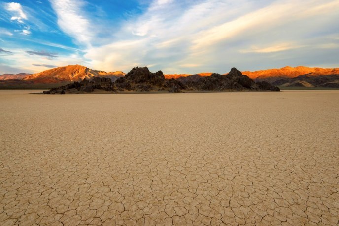
by The Goat | Mar 12, 2020 | Backpacking, Death Valley, Geology, Hiking, National Parks
Death Valley: 10 Cool Facts at 134 Degrees
There is a place so vast, so beautiful, so unique, and so special that it nearly defies comprehension. This is Death Valley. Located in the howling wilds of the Mojave Desert along the border of California and Nevada, Death Valley is at the same time magnificent and overwhelming in sheer size, beauty, and adventure opportunity. In our opinion, it is world-famous for all the wrong reasons. When most think of Death Valley, they think of it being the place where the hottest temperature on Earth was recorded; 134 degrees Fahrenheit to be exact on July 10, 1913. Even the name itself conjures up images of things literally bursting into flames; a place that is at the least not enjoyable, and at the worst, the terrestrial version of The Inferno.
While Death Valley itself does hold that distinction, the surrounding areas are quite pleasant during the summer months, and see up to feet of snow in the winter. The Goat aims to shed some new light on this wondrous, mysterious, gorgeous, and astonishing area, and he has put together his very best “Did You Know?” list about Death Valley!
1. Did you know that the vertical distance between the lowest and highest points in Death Valley is over 11,000 feet?
Telescope Peak, the highest peak in the Panamint Mountains that tower over Death Valley, is 11,049 feet above sea level. Its lofty peak is less than 15 miles away from the lowest point in North America, Badwater Basin at 282 feet below sea level. This nearly incomprehensible juxtaposition is a feat that is only accomplished by the complex tectonics and unique geology that govern Death Valley’s highs and lows.
2. Did you know that Death Valley should really be called “Life Valley?”
Death Valley National Park is home to numerous lizard and reptile species, bighorn sheep, antelope, snakes, Gila monsters, mountain lions, coyotes, foxes, several species of owl, rodents, and hundreds of plant and tree species including cottonwood, oak, Joshua trees, and various pines, as well as many species of cactus. The perception that it is a barren, lifeless desert could not be further from reality, as it houses one of the greatest biologically diverse ecosystems in the world.
3. Did you know that you can play golf then soak in hot springs in Death Valley?
You and the Devil. Furnace Creek Golf Club boasts a full 18-hole course that challenges golfers of all levels, and the Devil’s Golf Course is one of the most excellent salt flats in the world. Visitors to Death Valley can easily see both in a day, so get ready to dance with the Devil! After dancing, feel free to soak luxuriously in Furnace Creek Hot Springs, the park’s developed and fantastically rejuvenating hot natural hot spring.
4. Did you know that Death Valley is the largest National Park in the contiguous 48?
At 3.4 million acres, it dwarfs many of our National Parks including Grand Canyon, Yosemite, and even Yellowstone in sheer size. In fact, Grand Canyon and Yellowstone together would fit inside Death Valley!
5. Did you know that one of Earth’s rarest species exists in Death Valley?
The Devil’s Hole Pupfish, one of the most rare and beautiful species of fish in the world, exists in Death Valley and only Death Valley. In fact, the park is home to several species that are not just indigenous, but exist here almost exclusively.
6. Did you know that Mt. Whitney is in the next mountain range over?
Mt. Whitney, the highest peak in the contiguous 48 states at 14,465 feet above sea level, lies in the Sierra Nevada just west of Death Valley. This means that the highest and lowest points in the lower 48 are less than 100 miles apart!
7. Did you know that in 1929, not a single drop of rain fell in Death Valley?
Yep, not one. Death Valley is the driest place in North America, averaging less than 5 inches of rain per year. The howling deserts of places like Arizona and even the Sahara Desert of Africa average more, making Death Valley one of the driest places on the globe.
8. Did you know that Death Valley is home to some of the best-preserved human history sites in the Unites States?
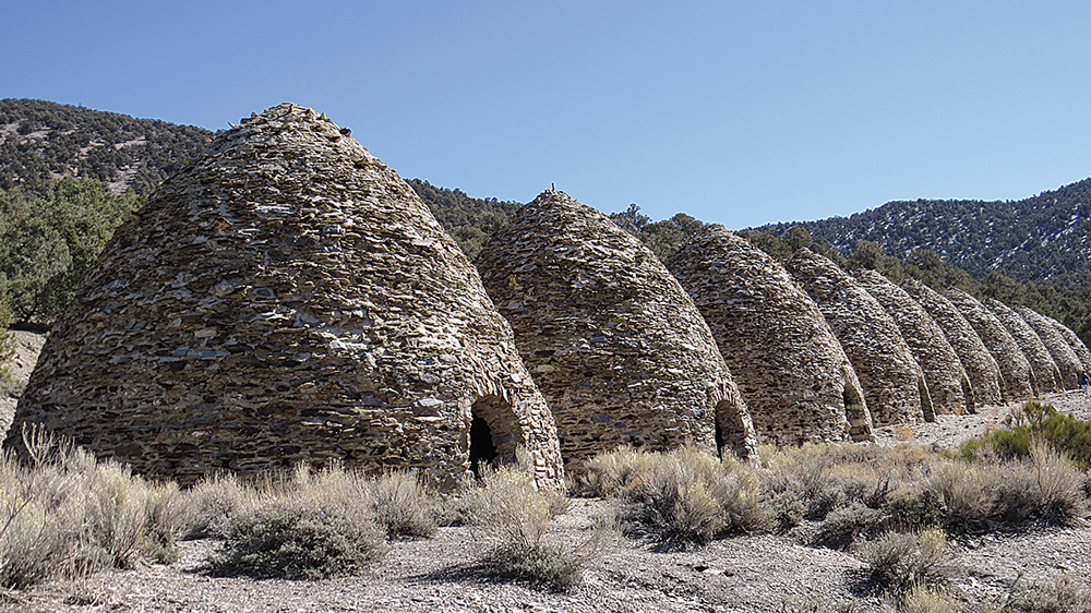
Both modern and ancient history are on fabulous display here in Death Valley. Archaeological evidence dates back to over 9,000 years ago, as petroglyphs and various Puebloan artifacts can be found all over the park. In addition, the Timbisha Shoshone Native American Tribe has called Death Valley home for over 1,000 years. There is colorful mining and European history here as well, as Death Valley got its name from frustrated and thirsty prospectors in 1848. There are numerous well-preserved mining claims and historical artifacts, and even a wickedly cool ghost town! (Check out our Surprise Canyon Backpacking Tour)
9. Did you know Death Valley is a favorite for Hollywood movie sets?
Dozens of scenes from Star Wars have been filmed in Death Valley, including Artist’s Palette (the Sandcrawler scene from Star Wars Episode IV: A New Hope), Golden Canyon (Jawa scenes from Star Wars Episode IV: A New Hope) and Mesquite Flat Sand Dunes (Droid scenes from Star Wars Episode IV: A New Hope). Also, cult classic film Tremors was filmed in the Owens Valley just one range over, and many of the shots in this excellent movie gaze onto the west side of the Panamint Mountains. Check out The Goat’s Geology Blogto learn more about Tremors and other great geology movies!
10. Did you know that Death Valley has some of the most outrageous geology in the world?
The geologic display in Death Valley is nothing short of astonishing. Home to three major faults, Death Valley is a wild melange of nearly-billion year-old sediments (very rare), contorted metamorphics, twisted volcanics, and more mineralization and hydrothermal staining than you could shake a geologic hammer at. A quintessential example of the extensional tectonics that have created the Basin and Range Province, Death Valley is not to be missed by the geologist child in all of us.
Bonus: Did you know that Death Valley can be a great place in all seasons (even summer)?
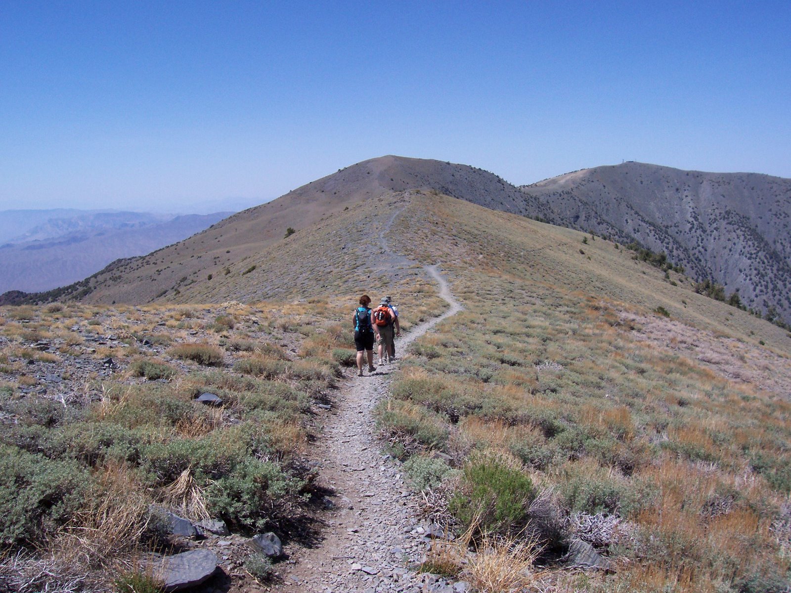
You read that right; all seasons, even summer. Crazy? Ridiculous? Suicidal? Nope, just the truth. The Panamint Mountains, which reach to over 11,000 feet, stay cool even as the summer heat blisters the valley below. This is a perfect time to summit many of Death Valley’s most lofty peaks, including Telescope Peak, it’s highest point.
Blue Marble Adventure GeoTourism is ecstatic to be rolling out our guided Death Valley hiking tours! Let our geologist/guides show you the wonder and whimsy of one of the most fantastically outrageous places on the face of the Earth. You’ll be glad you got past the name and into the wild!
May The Goat be always with you